Wednesday 24 October 2012

Travel to Bidadari & Tidung Island, Seribu Island, Indonesia


Bidadari (Angel) Island 
Pulau Bidadari dan Pulau Tidung
Angel Island is one of the Thousand Islands cluster of islands surrounded by large trees, this island formerly called Island Hospital and Pumered Island. Angel Island is inspired from the name of the other islands in the Thousand Islands as Island Princess, Island of Nirvana, and others. Geographically, the island is located between the cluster Onrust Island, Khayangan Island, Kelor Island and Pulau Ayer, Untung Jawa village, Southern District Thousand Islands and Thousand Islands regency.
Pulau Bidadari dan Pulau Tidung
The island was developed as a tourist destination due to its location in the Thousand Islands are beautiful and historic. In the 17th century, the Dutch built a hospital or a leper leprosy therefore first island called Pulau Hospital as with the Dutch also built a fortress that serves as a means of surveillance for defense from enemy attack. Until 1970 the island was not inhabited by humans, even the island has never been visited by people. In the early 1970s, PT Seabreez manage this island to serve as a tourist resort.

In addition to historical relics from the Dutch colonial era the main attraction of this island Angel Island has white sandy beaches with crystal clear sea water. Some rare plants such as the tree of peace (baringtonia exelsa), billowing trees, trees Sentigi (pempis acidula), ebony tree (Diospyros maritama), glodokan trees, some fruit trees, as well as mangrove forests growing and well preserved on the island.


Tidung Island
Pulau Bidadari dan Pulau Tidung
Spend your free time and leisure to walk in the mall, relax in the cafe, a movie may be plain and boring. If you want new things, such as enjoying the beautiful view of the beach, watching the beautiful coral reef, swim, enjoy the beautiful colors as the sun sets behind the horizon or just biking around the beach while enjoying the beauty and exchanged smiles with the locals. All of this can you dapakan Tidung Island.
Pulau Bidadari dan Pulau Tidung
Tidung Island is an island in the Thousand Islands, the island was nicknamed as Maladewanya Indonesia. Tidung Island is divided into two islands, namely Pulau Tidung Small and Large Tidung island connected by a bridge with a length of approximately 2 km. Until now Small Tidung uninhabited island, while the Big Island Tidung inhabited about 4,000 inhabitants, and one of the most populated island in the cluster of islands in the Thousand Islands.

Tidung islands whose width is estimated only 200 meters, but the length is about 5 km, surrounded by pristine white shades as shallow reef overgrown and filled with ornamental fish that never cease strutting shore. Beaches on the island is not big choppy because of the cluster of coral and coral reefs that surround the coast capable of withstanding waves so suitable for swimming.

Wednesday 17 October 2012

Traveled to Nusa Penida, Bali, Indonesia


Nusa Penida is an island next to the southeastern island of Bali, Indonesia. Administratively, the island is a subdistrict of Klungkung regency. There are two smaller islands nearby, namely Nusa Lembongan and Nusa Ceningan. Nusa Penida is the largest of the three islands. The water here is pretty cool (because ocean currents), and very clear, with gorgeous corals and prolific fish, with some turtle, shark (including gray reef and silver-tips) and in Aug-Oct - Mola-Mola Sunfish (weird and wonderful fish) a lot of it is here.

Diving locations in Nusa Penida ...

Manta Point

Nusa Penida DivingAt Manta Point Dive site Usually there are 3-4 Manta exploring this area. The condition here is that slope down to 50m. Not many corals, just limestone rocks. Besides Manta, you'll see a tuna, mackerel and other pelagics .... The waves are usually present here.

Crystal Bay

gamat bay dive areaCrystal Bay dive site to dive underwater cave system experience began about 10m of water and end up in a hole in the bat cave. Location located in a very nice white sandy beach lagoon. Currently, it can be tricky to start a business in a drop of about 20m. Underwater structure is excellent with a few variations and coral reefs and swim throughs. If the current is not strong, snorklers can enjoy the underwater scenery of the bay. Fish life is very rich and sometimes Sunfish and Nurse Sharks hide.

Gamat Bay

Nusa penida dive sitesGamat Bay dive site is located not far from the dive Toyapakeh. The water is always clear and the corals are steep, steep slope leading to the bay. In fact, Gamat bay is the only site on Nusa Penida terbauk that do not always require drift diving. Observation skills you need to see things in a macro which is located below the surface. It is full of caves and small cracks and various reef fish and invertebrates here is incredible.


lembongan bay dive areaMalibu Point

Malibu Point dive site is considered one of the best sites on Nusa Penida in addition to SD Point and Toyapakeh, is a little more wild than Toyapakeh with large schools of jack, rainbow runner, tuna, reef sharks and stingrays. There are quite a lot of sharks, and stingrays. Visibility is generally very good, at least 20m. There are also several large table corals.

Lembongan Bay

Lembongan Bay dive site is located in a protected area with water sports and pontoons. The site is shallow, 5 to 10m deep and offers a kind of soft and hard corals. Rich with coral reef fish species. This is a good place for beginner divers to for training. It's also good for snorkeling ...

Toyapakeh

Toyapakeh dive site is a very nice place for sheltered from waves and currents. Although the current is sometimes strong, usually it can be negotiated. There are many Blue Trigger fish at some point and near Pontoon, there are usually many Giant Trevally and Sharks. Corals fell to around 40m and is very healthy. Shallow area is excellent for snorkeling. Clear water with visibility up to 30m. Usually we can find some large pelagic fish here ...


Thursday 11 October 2012

Birds - Birds of Paradise Most Beautiful in the World, Papua Indonesia

Lesser bird of paradise (Paradisaea minor)


The Lesser bird of paradise known as the little yellow bird of paradise. This medium-sized bird with a length of about 32 cm, red-brown with a yellow crown and upper back kecoklatan.Burung yellow males have the throat emerald-green color, a pair of long tail feathers and decorated with ornate yellow wings in the white base in the outer regions. Female birds are smaller than males, having dark brown head, white chest and without feathers adorned ornament. Penyabaranya forest area covers the entire northern part of Papua New Guinea, and the islands near Misool and Yapen.

Raggiana bird of paradise (Paradisaea Raggiana)


The Raggiana bird of paradise is also known as Count Raggi's bird of paradise. This bird is also known as the bird of paradise. Habitat This bird is widely distributed in the southern island of New Guinea and northeast. It has a length of 34 cm long, red-brown-gray, yellow iris and feet grayish brown. Male birds have a yellow crown, emerald-green throat and yellow collar between the throat. Wing feather color varies from red to orange depending on the subspecies. Female birds are smaller than males, with a brown face and had no fur trimmings.

Astrapia Ribbon-tailed (Astrapia mayeri)


This is one of the most spectacular birds of paradise. His name Astrapia Ribbon-tailed and have the longest tail feathers in relation to body size, length is more than three times the length of its body. The length of the adult birds reached 32 cm with male birds that can reach 1 meter. Male birds have a black and green olive brown colored while the female bird. Males have the long tail-shaped white ribbon. Endemic area in the center of the island of New Guinea.

Blue bird of paradise (Paradisaea rudolphi)


His name reminds one of the name taxi transportation in Indonesia. This bird is about 30 cm, black, dark brown iris, gray legs. Male birds wing feathers decorated with the dominance of blue-purple. So it is also called the Bird of Paradise Blue. Blue Bird of Paradise is a bird endemic to Papua New Guinea. Endemic area covers southeastern highlands of Papua New Guinea.

Red bird of paradise (Paradisaea rubra)


We call it the Red Bird of Paradise, about 33cm long yellow and brown, and yellow beak. Adult males can reach 72cm including jewelry feathers are blood red with a white tip on the side of the stomach. Fur dark emerald green face and diekornya there are two long strap-shaped double gyre is black. Female birds are smaller than males, with a dark brown face and had no fur trimmings. Is endemic to Indonesia, Red Bird of Paradise is found only in lowland forests on the island and Batanta Waigeo in Raja Ampat, West Irian Jaya province.

Lawes’s Parotia (Parotia Lawesii)


Parotia lawesii medium size up to 27 cm). Regional distribution of forest covers the mountains in the southeast and eastern Papua New Guinea. Male birds have a black color with white forehead, nape blue iridescent purple and gold chest hair green. Decorated with three wire decorative head from behind each eye and elongated flank feathers black. Bird females brown with dark bird's head, sliced ​​yellow and dark.

King of Saxony bird of paradise (Pteridophora alberti)


King of Saxonyi is a small-sized babbler bird, with a length of about 22cm. Adult males have black plumage and yellow, his head there are two strands of wire scaly feathers glossy blue-sky like a banner reach 40cm in length and can be set at the time courting females. Therefore this bird eaten Paradise aloft. Fur coat and buttocks grow elongated shaped black hood. Iris dark brown, legs are gray-brown and black beak with the sea-green mouth. The females are gray-brown with lines and dark spots. Females are smaller than males and without decorated mantle decorations or wire wool. District mountain forests spread in Papua island.

Wilson’s Bird of Paradise (Cicinnurus respublica)


Wilson's Bird of Paradise rather small size up to 21 cm. Burun male is black with a red and yellow robe in the neck, light green mouth, blue legs and two purple tail feathers are curved. Semetara that females are brown with blue crown. Is endemic to Indonesia, with a spread in the hills and lowland rain forest and Batanta Waigeo Islands of West Papua.

Princess Stephanie’s Astrapia (Astrapia stephaniae)


Stephanie Astrapia measuring about 37 cm long, black bird with iridescent blue-green heads and purple, besides that it has a long black tail feathers keungunan. Females are dark brown bird with a black head blue. Natural habitat in the mountains of central

The following video dancing birds of paradise (Cendrawasih):

Panorama of Mount Rinjani Lombok, Indonesia


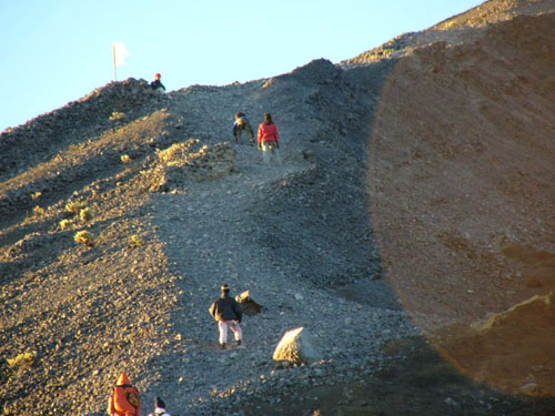
Mount Rinjani is a mountain located on the island of Lombok, West Nusa Tenggara. Mountain which is the second highest volcano in Indonesia with an altitude of 3726 m above sea level and is located at a latitude of 8 º 25 'latitude and 116 º 28' BT is a favorite for mountain climbers Indonesia for its beautiful scenery. This mountain is part of Mount Rinjani National Park has an area of ​​approximately 41,330 ha and proposed the addition so that it will be 76 000 ha to the west and east.

Administratively the mountain is under three districts namely East Lombok, Central Lombok and West Lombok. In the west there is a caldera cone Rinjani with an area of ​​3500 mx 4800 m, extends towards the east and west. In this caldera lake Segara Anakan are covering 11 million square meters with a depth of 230 m. The water that flows from the lake to form a very beautiful waterfall, flowing through a steep ravine. Lake Segara Anak there is a lot of carp and tilapia, so it is often used for fishing. With the blue color of the water, the lake is like the ocean child, because that's called "Segara Anak." The southern part of this lake called Segara Endut, and adjacent eastern New mountain there by local language called New Finger Mountain. which has a crater measuring 170 x 200 m with a height of 2296-2376 m above sea level. In 1994 New Finger mountain is erupting and spewing entrails around the lake Segara Anakan.


Geography
Mount Rinjani with a height of 3726 m above sea level, mendomonasi most extensive island of Lombok. Located adjacent to the eastern island, can be reached by direct bus from Jakarta to Mataram by using the ferry to cross twice (strait bali and lombok strait). Can also be reached by plane from Jakarta, Surabaya and Bali.


Ascent
Rinjani has panaroma is arguably the best among the mountains in Indonesia. Each year (June-August) visited by many nature lovers from local residents, students, nature lovers. Temperatures average about 20 ° C; lowest 12 ° C. Strong winds are common at peak in August. Lucky late July, the wind was still quite weak and the weather was pretty sunny, so summit attack can be done anytime.

In addition to the summit, a place frequented was Segara Anakan, a crater lake at an altitude of 2,000 masl. To reach this location we can climb from Senaru village or Sembalun Lawang (two nearest entry point at an altitude of 500 masl and 1,200 masl). Most climbers like the start entry of Sembalun direction, it can save 700m altitude. Sembalun route rather long but flat, and the weather is hotter because it is through the scorching savanna (winter temperatures but direct solar radiation skin burns). Sunblok cream is highly recommended.

While the direction of Senaru slope without a pause, but the weather krn gently through the forest. From these two locations takes about 9 hours to walk to the lip of the ridge at an altitude of 2700 masl (arrived at Senaru or Plawangan Plawangan Sembalun). In this place a view over the lake, as well as to the outside is very nice. From Plawangan Senaru (if rising from the direction of Senaru) down to the lake via a steep wall to a height of 2,000 meters above sea level), which can be reached in 2 hours. At the lake we can camping, fishing (Carper, Mujair) are aplenty. Lombok residents have a tradition of visiting soon tiller For soak in hot tubs and fishing.

To reach the summit (from the lake) had to walk up the wall as high as 700m west and up the ridge height 1.000m to be taken within two hours of stage 3 and 4 hours. The first stage towards Plawangan Sembalun, last camp to wait for the morning. Summit attack is usually carried out at 3 am to find beautiful moments - the sunrise at the top of Rinjani. Journey to the summit quite pretty, for climbing on the crater rim with a margin of safety that is mediocre. Terrain of sand, stone, soil. Last 200 meters altitude must be taken with great difficulty, as one step forward followed by a half-step down (fallen rocks gravel). Create highlander - this the most challenging and unpaid preferred because of the rough terrain with beautiful natural scenery. Mount Agung in Bali, Mount Ijen-Merapi in Banyuwangi and Mount Tambora in Sumbawa obvious when the weather is nice in the morning. To climb Rinjani unnecessary tools, enough stamina, patience and "passion".


Tuesday 9 October 2012

Faroe, the lake above the lake!


Unusual sights in the Faroe Islands, Denmark. Just imagine, here there is a lake which is above the other lakes. How come, huh?


If traveling to Denmark, a time to try to come to Faroe. Yes, this island is one of the beautiful places in the world who is also known for its scenery like a place in a fairy tale. The island is located between Iceland and Norway. Surrounding waters of the Atlantic Ocean is.


On the islands, there Vagar Island have unique lake. His name Leitisvatn, this is the largest lake in the Faroe Islands. From Amusing Planet, spacious lake is approximately 3.4 square miles.

Which makes this lake unique course because of the landscape. A cursory look, this lake has two flat surfaces like water. One is under the surface with a large enough size and another one on it with a smaller size. It sounds a bit absurd, but that's what you can see here.


But apparently, it's just an illusion. Too beautiful natural scenery of Lake Leitisvatn was always able to hypnotize any visitors. Overview of the lake is like a two-level, but when seen carefully it's not.

The lake is located just 30 meters above sea level is indeed divided by a hill. If you look from a higher position, the lake is seen as having two levels. This is because the shape of the hill about 100 feet high is a bit straighter.


This uniqueness can make Leitisvatn lake became very famous. Many tourists are curious about the pictures of this beautiful lake that have first spread on the internet. Most of them want to come to prove themselves scenery there.

As tenarnya Lake Leitisvatn, conflict arises among the local villagers, since the name of the lake comes from one village name only. Though the lake is also entered into the other villages. However, the Lake Leitisvatn already known. However, for mutual respect, local residents agreed to call it by a name Vatni which means a lake.

Birds Namdur, Designer greatest nest from Indonesia


This bird of pigeons. In an article published in the latest issue of National Geographic (July 2010), described as a bird Namdur architects and designers are very intelligent. He built a beautiful nest, then make decorations. He is good at sorting objects of interest to be placed in the nest so it seems aesthetically. His ability to sort something out and arrange them neatly is the equivalent of human ability and show a high cultural and aesthetic.

Remarkably, Namdur also painted nest. When building a nest, he organized hundreds of thin branches into two lines facing each other, as seen in this picture. In this way, Namdur build a nest shade. He then piled all the objects found in the environment surrounding the nest. For example, butterfly wings, feathers, car keys, or a few shreds of wrapping paper. This bird is most interested in the blue objects. As can be seen in the figure, birds gather in the nest all blue objects that can be found.

In addition, Namdur also use other means of decorating. More powerful, he sets up his own paint. Want to know how? Namdur collected plants of various colors and repainting the walls using plant extracts. Sometimes, he uses coal, mixed with saliva. Namdur also painted the nest, made ​​of twigs, with a piece of bark is chewed in the mouth.

Namdur birds can be encountered in Indonesia in Irian Jaya. Namdur birds nest maker is a whiz. At first many suspect the nest is made ​​of man-made, because of its unique and highly beautiful.But fact not the case, the nests it turned out just beautifully made ​​bird Namdur males.
Due to the nature of female birds Namdur materialist, and just want to mate with males that have the most beautiful nest, then what can make Namdur males must also be able to show off in enticing partner. Competition is tight.

To mengerjakkan a nest, bird Namdur takes a very long time, could be up to nine months, Wowww.Trus what if it turns out the nest that has been painstakingly built not able to pick up the heart of the idol of the heart. No, they will not destroy sarangkan frustration, but the nest will continue until there is a female decoration mau.Burung Namdur including monogamous animal species, although there are some that are polygamous.

In addition to great in making the nest, Namdur also known to mimic the sound of various animal species. Such as dogs, cats, tigers, goats, and more. Sounds like an animal used to repel animals tease approaching the nest. In making nests, bird Namdur using unique items he encountered, whether rocks, cloth human remains, the former flower pots, plastic and other leftover.


The Most Romantic Birds

For if a nest that aesthetically it? This time I went back dumbfounded. Let us dissect the mini-style signs. Namdur that make nests are Namdur males. Apparently he's prepared a wonderful nest to attract females. He is the type of bird that loves their partner and do nothing to satisfy his partner. All the beautiful picturesque it was built to attract females. In the end, he had to compete with other males, who are also thinking about the aesthetics of high-order alluring female birds.

The following collection of photos of birds nest Namdur :


Friday 28 September 2012

Travel to Tangkuban Perahu, Indonesia

Tangkuban Perahu or also commonly referred to Tangkuban Parahu is one of the biggest mountains in the plains Parahyangan. Nature Park Tangkuban Perahu Lembang north of town, north of the city of Bandung. The air was cool, the spread of tea gardens, valleys and tall pine trees accompany your journey to the gates of the Tangkuban Perahu.

There are two roads leading craters that exist on the mountain. The road first or the old road to the road conditions are more difficult to drive and usually will be closed after rain or when deemed dangerous to pass. The guard booth will give you instructions to pass new path which lies further to the top if the road is closed. Before the ticket payment on the first of these, there are cottages for rent for a place to stay.

Passing new roads, paved roads facilitate travel of your vehicle. On the side of the winding road there are trumpet flowers and other trees that will soothe your trip. In this area there are three Tangkuban Perahu crater of interest to visit. The crater is the Domas crater, Kawah Ratu and Upas crater. Craters are among the three biggest and most visited is the crater of the Queen. With a few hours of walking, you can even go around the vast crater of the Queen while enjoying the beautiful panorama of Mount Tangkuban Perahu.

KAWAH RATU (RATU Crater)

If you are coming by bus, special bus parking is available before reaching the crater of the Queen. The journey continues with ELF car that will get you into the crater of the Queen. However, if you use a private vehicle, you can continue to use it until the crater of the Queen. Vehicle parking is available across the crater, so without going through the difficult terrain and spend a lot of energy, you can see the crater. This might also be one reason, most visitors in this crater.

Kawah Ratu directly visible from the top of the wooden fence barrier to prevent visitors falling. Looking inside the crater, and the crater walls of smoke are still out of the crater it creates a thrilling sight. The ground around the crater of the Queen mostly white with some yellow brimstone. Rocks and the atmosphere is dry and arid felt in this crater. You can try to climb to higher ground if you want to see the crater of the Queen as a whole.

In this place many shops selling various souvenirs simple as scarves, hats skullcaps, handbags and fur hats, various displays of wood and various other accessories. There are also food vendors and warm drinks such as boiled noodles, bandrek and others. You also can ride a horse to go around most of the crater. This activity is usually favored children.

KAWAH UPAS (UPAS Crater)

Upas Crater Crater is located next to the Queen. However, to be able to see the crater is to go through dangerous terrain, you have to pass through a sandy path to reach the crater. Thus, it is rare visitors who come to see the crater. Different forms of Upas Crater Crater Queen. Kawah Upas more shallow and flat.

KAWAH DOMAS (DOMAS Crater)

Domas crater lies lower than the crater of the Queen. If you are dating through a new path, you will find the gateway to Domas crater before heading Crater Queen. If at Kawah Ratu you will only see the crater from a distance, the Domas crater, you can get closer to the crater. In fact, you can try to boil an egg by putting it into the crater. If you want to see past Domas crater at 16:00 pm, you are required to use the services of a tour guide.

MANARASA

Trees are widely seen around the crater is a tree called by the local people with the name Manarasa. The leaves of this plant will be colored reddish when old leaves. The leaves were already red edible with a taste similar to guava leaves with a bit of a sour taste. These leaves can treat diarrhea and is believed to be ageless. Maybe the leaves is believed by the people around always eaten by Dayang Sumbi youthful in the legend Tangkuban Perahu.


Jayawijaya and Carstenz Peak on Papua, Indonesia


Jayawijaya Peak is located in the tropics is a snow-capped mountain, you can rectify these assumptions after visiting Jayawijaya Peak, the highest peak in the Sudirman Mountains (Sudirman Range) in the province of Papua. Peak or a shorter Jayawijaya called Puncak Jaya, reaching a height of 4884 + meters above sea level (asl), allowing the area covered by eternal snow.

However, permafrost is expected to shrink, even drying. In a number of studies concluded that the deposits of ice in these mountains from year to year a serious shrinkage. Depreciation in the Sudirman Mountains snow is caused by global warming. Thus, it is not impossible to lose one day these mountains of snow as it does on Mount Kilimanjaro in Tanzania. Now, before it is actually estimated to be real, it could not hurt you to try to conquer the highest peak in Indonesia.

Jayawijaya Peak is one of the snowy mountain peaks that exist at the crossing of the equator, in addition to mountains in Africa and Latin America. When viewed from the air, Puncak Jayawijaya looks like a black carpet that was covered by a white hood. If the sun is bright, the snow will reflect the blinding sunlight. The content of the ice in the mountains is expected to reach 5 percent of the world's ice reserves outside the continent of Antarctica. However, due to global warming, the amount of shrinking year by year. When viewed from the type glaciers, snowy region Jayawijaya into the type of Alpine glaciation. While glacier (snow lumeran flow) in the region into the type of Valley Glacier, the glacier stream flowing from the higher towards the lower area. Therefore, in this area there is a possible flow of the glacier.

Besides known as Puncak Jaya, the highest peak is also known as Carstensz Pyramide, or the Carstensz Peak. The name was taken from an adventurer from the Netherlands, namely in January Carstensz, who first saw the snowy peaks in the tropics, specifically in New Guinea. The observation was made by Jan Carstensz through an ocean liner in 1623. Since not be proved by direct observation, the report was considered absurd. Because, for Europeans, find the snowy mountains in the tropics is something that is almost impossible.

The highlight of which is also listed as one of the top seven continents (Seven Summit), which is phenomenal and a coveted mountain climbers in the world. The peak is located in the National Park Jayawijaya Laurentz, Papua. The peak was covered by eternal snow. Eternal snow on Peak Jayawijaya is one of three snow fields in the tropics that are in the world. In our country it traversed the equator, watching the snow in Indonesia certainly something that is impossible to understand. Carstensz Pyramid (4884 m asl) is one of the snowy peaks. The highest peak in South East Asia and the Pacific is located in the Sudirman Mountains series. Peak is famous not only for its height, but also because there is a layer of snow on top.

Access to Jayawijaya Peak
Given the weight of climbing terrain, complex licensing process, as well as security when the ascent, the climbers should utilize the services of an experienced travel agent. Various travel agents who have an international reputation have provided two route options, the classical pathway through the Village Ilaga, or both pathways are more comfortable with a helicopter ride to base camp Hill Lake (Lake Valley).
The travel agent will usually also handle licensing issues, transportation from Jakarta to Papua, rental helicopter to base camp, climbing guides, insurance, and training and conditioning team before the climb. Of course, the cost per person for a team ascent by using a travel agent requires considerable cost, which is about $ 10,000 per person (or about one hundred million dollars more).


Top of Carstenz Peak

Carstensz Pyramid peak has an altitude of 4884 M above sea level (16,023 ft). Location is at the coordinates 04 ° 04 733 S and E 137 ° 09 572, located in the west central highland called a Sudirman Jayawijaya and mountains. Many think that the same Jayawijaya peak Carstensz Pyramide, the two adjacent peaks located.

In 1623 John Carstensz Navigator of the Netherlands became the first to bring the word to Europe about the existence of the ice caps in the tropical western equatorial line eografis Papua New Guinea. The results of the report met with laughter by the public at the time. New in 1899, the lapse of three centuries of Dutch expedition was to create a map in there to justify what is conveyed John Carstensz. Then immortalized his name in there.

This mountain is located in Indonesia, but the climbers were graced by exploring punggungannya most climbers instead of abroad is not local climbers. You know, every year there are about 200-300 foreign climbers explore this mountain, while Indonesia only tens orangsaja climbers. It looks strange, but it is a fact that happened on the field. Investigate a local climber investigate constrained in terms of licensing.

To climb this mountain there are two accesses, through freeport and Ilaga. Galih Donikara, a senior Wanadri mention to climb this mountain must have a recommendation from the Office Affairs, Police, BIA - Indonesian intelligence, Menhutbun / PKA, PT Freeport Indonesia (PT-FI). If you want to pass Tembagapura plus of Indonesian Rock Climbing Federation (FPTI). It all should be taken care of in Jakarta. Then in Jayapura, the recommendation of Police Chief Bakorstanasda and have bagged. In Timika, on EPO and PTFI permission for the track facility. "Last in Tembagapura, coordination with the Emergency Response Group (ERG) for handling Emergency Procedures and apparatus Satgaspam to track security issues," said mountaineer who had joined the expedition of Indonesia - Everest '97 is. The series is a long list of letters of recommendation that eventually many of us prefer to make climbers climb abroad. As for access Ilaga, it takes even more cost and longer time to reach the base camp.

Borobudur Temple, Indonesia


Borobudur is the largest Buddhist temple in the 9th century measuring 123 x 123 meters. Borobudur was completed centuries before Angkor Wat in Cambodia.

This Buddhist temple has 1460 relief panels and 504 Buddha effigies in its complex. Millions of people are yearning to visit the buildings included in this World Wonder Heritages. Not surprisingly, since architecturally and functionally, as the place of worship, Borobudur is attractive.


Punden terraces Borobudur-shaped building comprises 10 levels. Height 42 meters before being renovated and 34.5 meters after the renovation because the lowest level is used as a barrier. Six lowest level of a square and three levels above and a circular highest level of Buddhist stupa facing to the west. Each level represents the stages of human life. In accordance schools of Mahayana Buddhism, every person who wants to reach the level of Buddha must through every level of life is.

Borobudur was built by King Samaratungga, one of the king of the ancient Mataram kingdom, descendant of Sailendra dynasty. Based on the inscriptions Kayumwungan, an Indonesian named reveal bahwaBorobudur Hudaya Kandahjaya is a place of worship that was completed on 26 May 824, almost one hundred years since the beginning of construction. The name of Borobudur, as some people means a mountain having terraces (budhara), while the other says that Borobudur means monastery on the high place.

The base of Borobudur, called Kamadhatu, symbolizing human beings that are still bound by lust. Four levels above referred Rupadhatu symbolizing human beings that have set themselves free from lust but still bound manner and form. At these levels, a statue of Buddha placed open. Meanwhile, three levels above where the Buddhist stupas are laid in holes called Arupadhatu, symbolizing human beings that have been free from lust, appearance, and shape. The top part is called Arupa symbolizes nirvana, where Buddha is residing.

Each terrace has beautiful relief panels showing how skillful. Relief that will be read coherently when you walk in a clockwise direction (towards the left of the entrance of the temple). In reliefnyaBorobudur tells of a legendary story, the Ramayana. In addition, there are relief panels describing the condition of society at that time. For example, relief of farmers' activity reflecting the advance of agriculture system and relief of sailing boat representing the advance of the cruise, who was based in Bergotta (Semarang).

All relief panels in Borobudur temple reflect Buddha's teachings. Hence, this temple functions as educating the media for people who want to learn Buddhism. YogYES invites you to surround each of the narrow alleys diBorobudur order to understand the philosophy of Buddhism. Atisha, a Buddhist from India in the 10th century once visited this temple that was built 3 centuries before AngkorWat in Cambodia and 4 centuries before the Grand Cathedrals in Europe.

One question that is still unanswered about Borobudur is how the condition around the temple was built and why the temple was found in the buried. Some mengatakanBorobudur originally stood surrounded by a swamp and then buried by the eruption of Merapi. Calcutta is essentially the inscription reads 'Amawa' means sea of ​​milk. The word which is then interpreted as Merapi lava. Some others mengatakanBorobudur Merapi cold lava buried.

Monday 24 September 2012

Knowing tribe Asmat, Papua, Indonesia.


Asmat is the name of a tribe of the largest and most famous among the many tribes in Papua, Irian Jaya, Indonesia. One of the things that made ​​the Asmat tribe well known is the result of traditional wood carving is very typical. Some ornaments / motifs that are often used, and the main theme in the process of sculpting a statue made ​​by the Asmat tribe is the theme of the ancestors of their tribe, commonly called mbis. But do not stop there, often also found ornaments / other motif that resembles a boat or wuramon, which they believe to be a symbol of the boat that brought the spirit of their ancestors in the underworld. For the Asmat tribe of natives, wood carving rather a manifestation of the way they perform rituals to commemorate the souls of the ancestors.

Asmat tribe spread out and inhabit the sea around the coast and the mountains Arafuru Jayawijaya, with a fairly heavy considering the terrain occupied area is wilderness, in the life of the Asmat, a stone that we usually see on the streets was very valuable to them. In fact, the stones can be used as a dowry. All of that is because the places that set up a live Asmat swamps making it very difficult to find stones street which is very useful for them to make axes, hammers, and so on.
Asmat population in general have distinctive physical characteristics, black and curly-haired. Her body is quite high. The average height of the Asmat women around 162cm and height 172cm men reach.
One thing that enviable lifestyle of indigenous tribes asmat, they feel he is a part of nature, that is why they are very respectful and keep the natural surroundings, in fact, around the tree of life where they are considered to be a picture of himself. The trunk describe hand, describes the chief fruit and roots describe their feet.


Asmat people daily work surrounding environment, especially for foraging, hunting and gardening in a way, which is still using the traditional method and simple enough. Asmat cuisine unlike our cuisine. Special dishes for them is sago worm. But everyday they just grilling fish or meat of animals hunted.